CPS Resource Centre
Checklist Editor Mark Honig has finalized the first 2026 update of the MoS Checklist (January 2026 to June 2026). This new update, along with previous updates, are always available as Microsoft Excel files to download from the “Checklist Updates” section on the MoS Checklist page.
|
|
|||||||||||
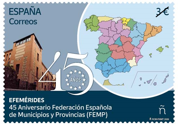
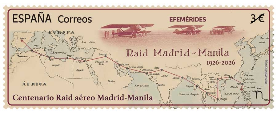
At the Boston World Stamp Show 2026 the CartoPhilatelic Society (CPS) presented a donation to the American Topical Society (ATA) in recognition of the many contributions that David Wolfersberger made to the CPS and to the broader field of carto-philately. The donation of $US5000 from individual CPS Members in memory of David was presented to ATA President Jeffery Hayward by CPS Treasurer Phil Coop on May 25, 2026. CPS Vice-President Lynn Vernon, who arranged for the donation, also attended the show. David was earlier recognized by the ATA with their highest award as Distinguished Topical Philatelist of 2022. Spanish Post recently issued two commemorative issues of high cartophilatelic importance. On each issue the ‘ñ’ symbol represents the domestic postal‑service denomination, while the 3€ price the fixed face value of the commemorative stamp (Efemérides) and does not correspond to the domestic postal rate, in our understanding.
The March 27, 2026, issue marks the 45th anniversary of the founding of the Federación Española de Municipios y Provincias (FEMP) — the national association representing Spain’s local governments. Founded on June 14, 1981 by a group of 20 mayors who sought to create a unified national body for Spanish local governments. Today, the FEMP includes 95% of Spain’s municipalities, plus provincial and island councils. The 58mm x 41mm stamp features a colorful thematic map of Spain’s autonomous provinces, island councils and autonomous cities. Also visible is a portion of the north coast of Africa. While not visible on the current image one assumes that the autonomous areas of both Ceuta and Melilla are shown on the stamp. In the lower right of the map is an inset showing the two provinces of the Canary Islands: the four islands of Santa Cruz de Tenerife (left) and the three islands of Las Palmas (right). On the left side of the stamp is an image of the façade of the FEMP headquarters in Madrid. On April 1, 2026, Spanish Post issued stamp commemorating the Centenary of the Madrid–Manila Aerial Expedition, 1926.
In 1924, Spanish military aviators proposed an ambitious aerial expedition to the Philippines to showcase Spain’s aeronautical progress. Delayed until 1926 due to late aircraft deliveries, the mission—named the “Elcano Squadron” in honor of Juan Sebastián Elcano — departed Madrid with three Breguet XIX biplanes. After numerous difficulties, only one aircraft, the “López de Legazpi,” successfully reached Manila on May 13, 1926, completing the 17,000‑kilometer journey over 39 days and more than 106 hours of flight. The aviators carried official messages and private correspondence along the route. Upon arrival, Manila applied two special commemorative hand‑stamped markings to the transported mail, prepared specifically for the occasion and certified by the local postal authorities. The horizontal layout is approximately 75 mm x 29 mm and primarily features a map depicting the route the expedition flight traveled from Madrid to Manila. The map shows the then-existing boundaries of the countries transited and major waypoints along the route. In the upper right of the stamp is a stylized vignette of the three aircraft on the landing strip. Asking Microsoft Copilot to describe the stamp image resulted in this well-written bit of copy, “The stamp is rendered in a warm, sepia‑toned palette of ochres, rust reds, and parchment creams, giving it the feel of an aged flight log or expedition map. A bold, stylized map dominates the composition, its simplified landmasses and thick route line recalling early air‑navigation charts. In the upper right, a soft vignette of three ghosted aircraft drifts across the background, their translucent forms evoking archival photographs. The layered, poster‑like design blends vintage aviation aesthetics with modern graphic clarity, creating a commemorative piece that feels both historical and contemporary.”
Checklist Editor Mark Honig has finalized the third and final 2025 update of the MoS Checklist (June 2025 to December 2025). This new update, along with previous updates, are always available as Microsoft Excel files to download from the “Checklist Updates” section on the MoS Checklist page.
David was responsible, together with the late Alf Jordan, Lilian Kent and Bill Critzer, in reviving the CartoPhiltelic Society from its hibernation between 1995 and 2003. Since then, David became a pillar of the CartoPhilatelic Society (CPS), serving as President, Vice-President, and Editor of The New CartoPhilatelist, the Society’s quarterly journal. He was instrumental in maintaining the Maps on Stamps (MoS) Checklist through the Society’s hibernation. Acting as Checklist Editor from 2003 until his death, David meticulously researched and oversaw its expansion to nearly 42,000 entries. David was a lifelong philatelist and was honored by the American Topical Association (ATA) as its 2022 Distinguished Topical Philatelist. His philatelic interests were wide and varied, and his dedication to a number of philatelic societies and study units was tireless. In recent years David served as acting editor of Enophilatelica (Wine on Stamps) and The Philatelic Gourmet (Gastronomy Stamps), as well as The New CartoPhilatelist. David shared an exuberance for carto-philately and our members will fondly remember their interactions with David for many years to come. Our deepest sympathies are with David’s wife Kathleen and his family at this time of loss. A public notice has been published, and an additional notice will appear in the next issue of The New CartoPhilatelist.
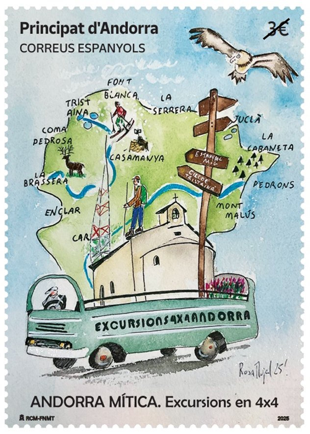
Spanish Andorran Post, released a stamp as part of its “Andorra Mítica” or ‘Legendary Andorra‘ philatelic series that highlights the country’s history of adventure tourism. The June 4, 2025 issue focuses on excursions taken in 4×4 vehicles and celebrates a vibrant period in Andorra’s past, especially during the 1960s and 1970s. During those decades, Andorra experienced a tourism boom, driven by increased economic prosperity in nearby France and the rising popularity of holidaying in Spain. Tourists were drawn to Andorra for its scenic beauty, affordable prices, and shopping opportunities. Within this flourishing context, several local companies began offering guided tours in off-road vehicles to showcase the country’s rugged and remote mountain terrain. These tours became iconic, with operators modifying buses and SUVs to create open-air, safari-style vehicles complete with cut-off roofs, benches in the trunks, eye-catching colors, and bold signage. These unusual vehicles became a familiar part of the Andorran mountain landscape during that time. This single stamp issue features a vertical layout, depicting an open-top bus marked “Excursions 4×4 Andorra” in the foreground. Behind the bus, a stylized map of Andorra serves as the background. The design also includes illustrations of various tourist activities, a church, a directional signpost with city names, local wildlife, and topographic annotations. The stamp carries a denomination of EUR 3 and is valid for international mail. The stamp commemorates this adventurous spirit and serves as a nostalgic tribute to a time when tourism helped shape Andorra’s identity. Although Andorra lacks its own postal administration, both Spain and France operate postal services within the principality. Domestic mail is free, and stamps issued by the Spanish and French postal services in Andorra are used exclusively for international correspondence. |
The CartoPhilatelic Society is proudly affiliated with the American Philatelic Society and the American Topical Association. Visit there web sites and learn about their activities.
|
||||||||||
|
Copyright © 2026 The CartoPhilatelic Society - All Rights Reserved
About this web site: If you have any questions, comments or suggestions about this site, please contact the web site administrator. Unless otherwise stated, all content, images, text, separate files, on this web site are the Copyright of The CartoPhilatelic Society, and may not be used without written consent of the President, CartoPhilatelic Society. Powered by WordPress & Atahualpa |
|||||||||||
 Donation to ATA recognizes the cartophilatelic contributions of David Wolfersberger
 It is with profound sadness that we report the sudden death of Mr. David Wolfersberger on October 24, 2025.